Sunday, August 27, 2006

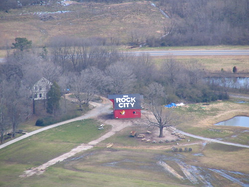
The Rock City Barn I missed several times.

here it is, right on the side of the interstate, on top of a hill. How could I miss it? The stretch of long-distance Interstate driving I am on more than any other is probably Interstate 24 between Nashville and Chattanooga. If you are traveling Eastbound, right after exit 155, the Freeway splits as the Eastbound and westbound lanes separate for a short distance. If you are traveling westbound, the split starts right after you cross the Tennessee River (and Nickajack Lake) at Exit 158. There is a fireworks store between the lanes. I always wondered how someone would be lucky enough to get a store of any kind between lanes of an interstate. At this same spot, if you looked to your left, there used to be a Rock City Barn wishing you goodbye. Sadly, it has been removed in the past 10 years. Pictures of the Goodbye Barn are Here.

Let's move back to the split in the eastbound direction. The land of that area is used to display tractors and other various farming equipment for sale. There were probably 50 of them in nice rows. This caught my attention. It is difficult to take a good picture from a moving car. It's worse when you are on the interstate and on the passenger side looking at something on the left. It came out horribly blurry:
This is a horrible picture
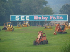
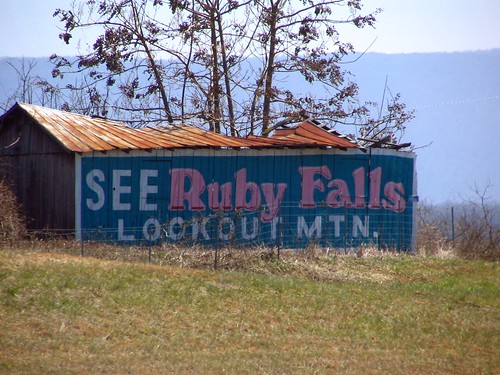
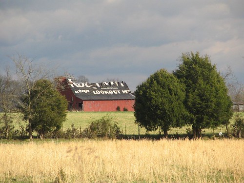
I did think it was neat how all the tractors were in the foreground with the See Ruby Falls extra-wide billboard was in the back. However, I was severely bummed that this picture didn't come out well. I couldn't wait for my next opportunity to try again, which came a few months later. It rained that day. Months later, I had another chance, and it was sunny. When we were about 30 seconds away, I took this test picture:
Tractors
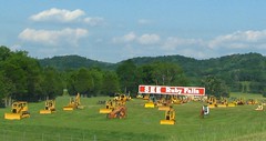
(Side note: the Ruby Falls billboard was repainted a different color.)
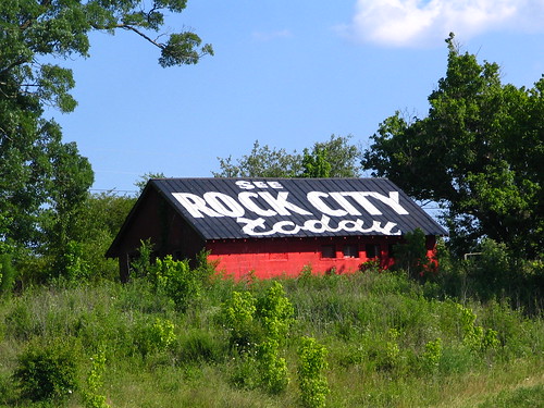
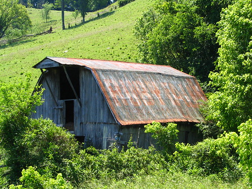
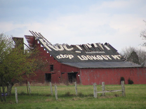
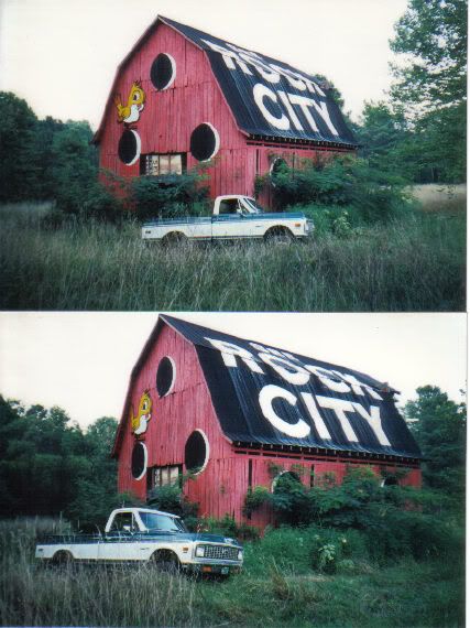
While I was getting ready to take my good shot, my wife asked, "what is that Rock City thing on top of the hill?" We pulled over and stopped the car.
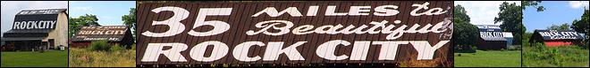
See Rock City Today

SEE
ROCK CITY
today


This is Barn #10, the Joe D. Thomas Barn in the Capps Book.
This is on Page 159, top center in the Jenkins Book.
OhioBarns.com lists this as #RCB 42-56-02.
It is located in Marion County, and you can see it on a map here.
Lat & Lon: 35.043471 N / 85.609154 W

Saturday, August 26, 2006

Crumbling barn with multiple advertisements

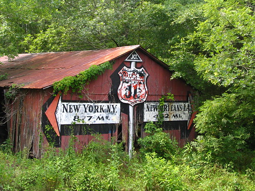
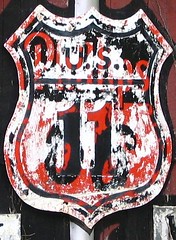
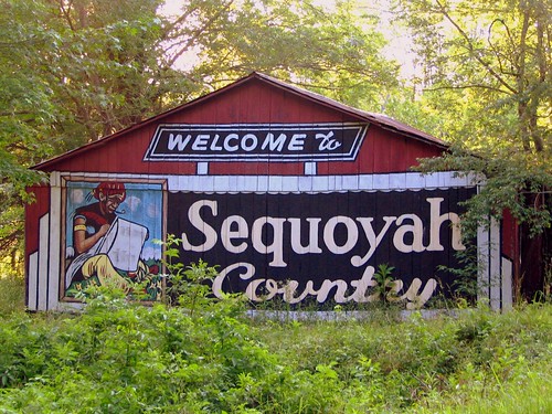
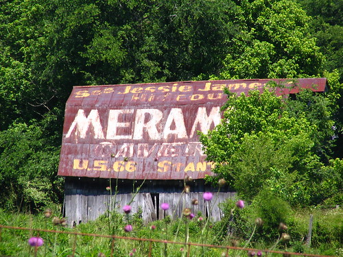
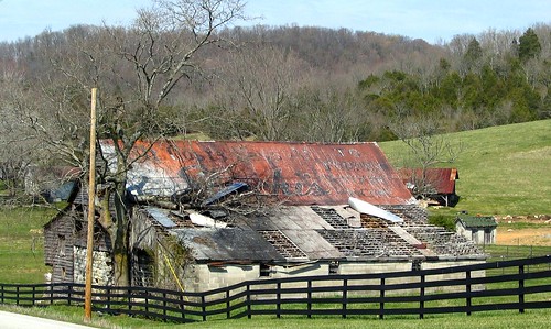
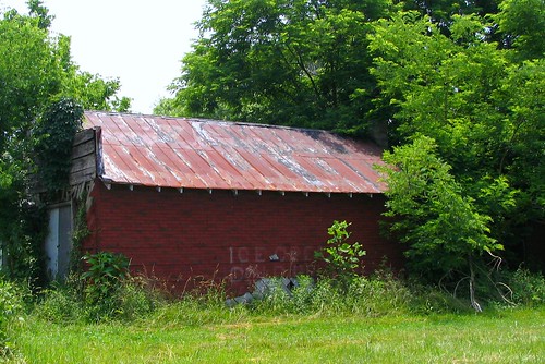
ne dilapidated barn in Northwest Georgia is falling apart but still has four old advertisements on it. Three are visible in the first picture, with the 4th around the corner. Closeups will be available for each.
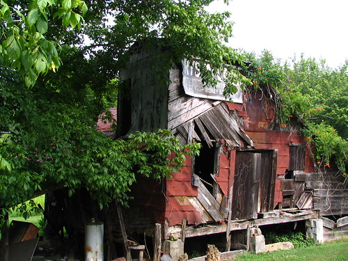
Click to enlarge

This barn is on U.S. Highway 11 just South of Trenton, GA in Dade County. Once this highway was a primary route between Chattanooga and Birmingham, but with Interstate 59 running parallel most of the way, it sees much less traffic, and there would be no incentive to maintain the ads.

Click to enlarge

First, on the left side of the barn, with a message facing northbound traffic was a small painting of the words "SEE ROCK CITY" except much of the black and white paint has chipped away. This portion of the barn is made of corrugated metal, and a strip of it on the left has fallen off, and has taken the R of Rock and the C of City with it.

Click to enlarge
Facing the street, the cracked sign which has been nailed onto the barn reads:
CRYSTAL CAVE
CHATTANOOGA'S BEST ATTRACTION
OR YOUR MONEY BACK


Crystal Cave in the early 1970's was renamed to Raccoon Mountain Caverns but they still retain the Crystal Cavern tour. To the right of the Cave sign is a metal gas station sign that has completely rusted and has become mostly obscured by greenery. If you recognize it, please help me out.

Click to Enlarge

On the side of the barn visible to southbound traffic, the "See" of "See Rock City" is still visible. What I can't tell is if the barn has been rebuilt at one point, covering up the words "Rock City" or if the "Rock City" part was painted on the slanted side.

OhioBarns.com lists this as #RCB 10-41-02.
In the Jenkins Book, Page 136, Top Center.
See it on a map Here.

Friday, August 25, 2006

How far to New York or New Orleans on U.S. 11?

his photo has become one of my favorite subjects, and is also one of the rare times that I have had a chance to go back and rephotograph something that I wish I had done better the first time. This barn is painted on both sides and also also has a roadfan element to it.

click photo to enlarge

This barn is at the primary entrance and exit to Sequoyah Caverns in DeKalb County, Alabama. (I will write more about Sequoyah Caverns in a different blog post.) Upon leaving the Caverns, motorists are presented with a choice. Turn left and you are 877 Miles from New York, New York to the North, or turn right and you are 462 Miles from New Orleans, LA to the South.

To arrive at Sequoyah Caverns, signs point you onto U.S. Highway 11, and then onto County Road 731. Then, when your visit is done, you would get back on U.S. 11 with this barn at that intersection. U.S. 11 does go all the way from New Orleans to the U.S. / Canadian Border, north of Syracuse. (Ironically, it does not pass through New York City.) This highway was established in 1926 and follows much of the same route then as it does now, although it has been lengthened to 1645 total miles in 10 states.

The metal pole in the center is an actual pole, not painted. The small triangular JCT. sign at the top has been affixed onto the pole, just as the U.S. 11 Shield has been. The black "shadow" of the U.S. 11 shield was painted on the barn, just like the arrows. The U.S. 11 sheild's paint has worn down to the point that you can see it used to be a sign for Phillips 66 gas stations. The black paint looks to have worn off much faster than the white paint on the sign.

Click photo to enlarge

Did this used to be an advertisement for Phillips 66 gas stations? If so, at some point, they must have dropped their sponsorship and U.S. 11 was painted over the Phillips 66. This was my Original conclusion. However, now I think the painter was just looking for a metal sign that was the correct shape and found an old Phillips 66 sign and painted over it. This barn likely would not have been a Phillips 66 ad unless there was one in either direction, I would think.

The other side has been better maintained.

Welcome to Sequoyah Country

When you follow the signs to get to the caverns on U.S. 11, this marks the entrance off the main road to go less than a mile to the parking lot for the Caverns. The Portrait on the left, I would assume, is Sequoyah devising the Cherokee alphabet.

It has been a long time, if ever, that this has been used as a barn, as it is inaccessible, unless you cut through the tall grass and weeds. There is a small stream between me and the barn when I took the first photo. There is a line of trees on the south side and the street to its north, but now is slowly becoming "reclaimed by nature."

I had never really paid attention to Sequoyah Caverns until I had driven U.S. 11 in pursuit of some Rock City Barns, but after a chance to research it more, my wife and I made a point to see it soon thereafter. More of their advertising barns will be discussed later.

Read more about Sequoyah Caverns, Here.
See it on a map, plus its aerial image Here.
My original photo is Here:New York or New Orleans?

Thursday, August 24, 2006

See Ruby Falls on Interstate 24

Click on photo to enlarge


SEE RUBY FALLS
LOOKOUT MTN.


This wooden barn with a rusty and warped metal corrugated roof is along Interstate 24 with the same Cumberland Plateau that includes Monteagle in the background. The Ruby Falls barns have simpler messages than the Rock City Barns, but have a more complex Color Scheme. This uses their trademark colors of Ruby Red and Turquoise. The "Ruby Falls" is painted in Pink, but outlined in a darker red and white to give it a 3D look.

On Ohiobarns.com, is listed as #RFB 42-74-02 but is mislocated in Robertson County. It is really in Rutherford or Cannon county south of Murfreesboro, TN but north of Manchester.

Wednesday, August 09, 2006

See Ruby Falls and Meramec Caverns

nce a Rock City barn, this has changed to advertise Ruby Falls and Meramec Caverns. If you live in the not-so-deep south, if you were to think of an advertising barn, you'd think of the many "See Rock City" barns that used to be all over the countryside. This barn used to be one of those. At some point, however, their rival barn-painting (albeit not so prolific) tourist trap from Lookout mountain were permitted to repaint this barn with a "See Ruby Falls" message in their colors of red and turquoise.

This barn is on U.S. Highway 41 right on your map where it says Noah, TN in Coffee County, just north of Manchester. With the construction of Interstate 24 about 40 years ago, this highway is less often used now. So this was probably painted before then, and would have been a rock city barn before that. Rock City Paint was some high quality mixture, and has been known to outlast many things. Is it possible that the ruby falls paint has chipped just enough that the Rock City white is beginning to show? I think you can make out the letters of Rock City along the bottom of this barn. You can click on the picture to enlarge it.


See Ruby Falls


SEE
RUBY FALLS

Now, on to the other side. Meramec Caverns is indeed along the Mother Road, the Old Route 66, so now think how long ago this was probably painted. The newer barns for Meramec Caverns tell you it's located off I-44. These ads are plentiful in Missouri, but many of the remaining painted barns in the south are for Rock City.

Meramec Caverns Barn

See Jessie James
Hideout

MERAMEC
CAVERNS

U.S. 66 STANTON, MO

OhioBarns.com lists this as #RFB 42-16-01 and #AdB 42-16-01
In the Jenkins Book: Page 71.
In the Simmons Book: Ruby Falls side, page 60-61; Meramec side, Back Cover and Page 67.
See it on a map here.
An alternate view from quillus is HERE.
Lat & Lon: 35o34'33.96" N / 86o11'31.68" W

Tuesday, August 08, 2006

See Rock City for $3.99

This was one of my favorite items for sale in the Rock City gift shop.

See Rock City for $3.99

This is exactly what it looks like. On the floor, it's a flower pot full of See Rock City Barn shaped birdhouse pencil-toppers on the floor of the Rock City gift shop. However, I bought one that was a Christmas Tree Ornament instead. They also have poofy hats that are shaped like this.

Monday, August 07, 2006

It Costs Less at Sterchi's

Not all of my posts will be long-winded or even focus solely on Rock City Barns.

It Costs Less at Sterchi's

the barn reads:
It Costs Less at
Sterchi's
TO FURNISH YOUR HOME
(the last 4 words are on the right)

They probably can't help if you need to refurnish your barn after a tree falls upon it. I had never heard of Sterchi's Furniture store until this barn. I saw 2 of these in Lincoln County, TN. The other was on U.S. Highway 64. This one looked better. It's on U.S. Highway 231 just north of Fayetteville. I am not sure what color the barn was originally painted, but it is always nifty to see old painted metal barns where the old different paints rust into different colors.

The very approximate location on a map.

Sunday, August 06, 2006

Crumbling Barn on U.S. 41A

rumbling barns are not uncommon, but sometimes, they make me sad. You can see barns that are falling apart all over the place. Sometimes, it's because of heavy wind or other weather conditions, sometimes because the wood is rotting, and other times because they are too close to the road. Some barns are held up by one well reinforced side and some appear to be held up only by vines and the grace of God. Barns one day might become an Endangered species. Sure, they are common now, but today's farmers have less of a need to build new ones. Most of the barns we see these days are decades old, such as this one:

Rock City Barn, Bedford Co., TN

at one time, this said...(take my word for it.)

SEE BEAUTIFUL
ROCK CITY
atop LOOKOUT MT


This barn was built in 1918 by the same family that first bought the land in the 1830's and resides their today. Four score and seven years after its construction, I drove by. That was a year ago. It might not be there anymore. I'm not sure I want to find out.

crumbling rock city barn


This barn is located along Highway U.S. 41A (sometimes labeled on a map as Alt 41). It is south of the 31A / 41A split, and about 5 miles south of the small town of Eagleville, TN in Bedford County. If Rover, TN is on your map, that is a better approximation. The first picture was taken from Beasley Rd, which is just north of the Barn.

In the mid 90's, during its better days, this barn served as the cover of the Capps book: (and is also barn #16)


OhioBarns.com lists this as #RCB 42-02-01. (which has two additional photos one with less and one with more decay.)
In the Jenkins Book, page 154 top right
Here it is on a map.
Lat & Lon: 35o 40' 60 N / 86o 36' 26" W

Saturday, August 05, 2006

See 7 States - along the old route

his building was on the main road many decades ago, but now gets minimal traffic. In the dawn of car travel, the main highways winded their way from city to city. Since then, there has been a bigger emphasis on getting to your destination quicker. If it is an important route, an Interstate has been built to supplant the old highway. A highway that still gets significant traffic has been straightened, widened with more lanes and bypasses the town square or city center. Many people prefer it this way as the drive to where you're going is a necessary evil that should be as short a duration as possible. However, for me, and people like me: Half the fun is getting there.

Highway U.S. 27 is the route used to get from Cincinnati and Lexington to Chattanooga. Most people who would make this trip now would use Interstate 75. Still, there is significant traffic along U.S. 27 and in many places, the highway has been straightened and widened. Many Rock City Barns have been lost due to this process. However, a significant portion of the Old U.S. 27 has been redesignated as Ky 1247. Along this highway in Pulaski Co., between the town squares of Eubank and Somerset, you will find this old store bearing the See Rock City painted sign.

See 7 States from ROCK CITY

SEE 7 STATES from
ROCK CITY
NEAR CHATTANOOGA, TN

This appears to be an old convenience store whose best days are behind it and is slowly becoming "reclaimed by nature." The sign has obviously not been painted for decades. This would not really be a good location for an ad for a tourist destination nowadays as this area primarily only sees local traffic.

The bricks in the center of this side of the store are staring to fall off, showing the diagonal wooden frame. Even some of that wood is missing, also. Spray painted in white in the same area are the words ICE CREAM and COLD DRINKS. Although completely covered, there is a window to the left of the front door. You can still access the front door. Barely. The chimney is still barely visible at the back. There is even a small storage building behind the building. When painted, this still would have been white lettering upon a black background, but the white area rusted reddish while the black paints seems to only fade or chip away.

OhioBarns.com lists this as #RCB 17-100-1
In the Jenkins book on page 141 top left.
See it on a map here.
Lat & Lon: 37o12'48.11" N / 84o38'19.87" W

Friday, August 04, 2006

The Birdhouse Barn near Rock City

ne Rock City barn can be seen from Rock City, but it hasn't always been there. One of the bigger draws to rock city is the claim you can see seven states from the Lover's Leap overlook. You are in Georgia, while Tennessee is not far to your left, while Alabama is just a few miles to the right. The Carolinas are many miles strait ahead, and it is debatable that you can actually see Kentucky or Virginia. If you look down, you will see the tops of trees down the side of the mountain until it gets to the flat area at the bottom. There are several fields while the Chattanooga Valley Highway (GA 193) runs parallel with Lookout Mountain.

The Rock City people have bought one of those fields, the one which appears in the top left corner in the picture below. Every year during the autumn season, they have a maze grown out of stalks of corn, which they call The Enchanted Maize. In that field is a rock city barn, which only looks like a white dot on a black speck in the first picture.
See Seven States
The sale of Rock City birdhouses have now complemented the painting of barns for their advertising. The concept was originated by the Barn painter Clark Byers who, along with his son, first painted this barn in the late 60's. It was originally located just off Interstate 75 in Dalton, Ga, however the overgrowth of trees made it difficult to see from the freeway, unless you stopped at just the right spot. (Here is an example photo of a birdhouse.)

Not too long ago, the church that owned the property decided to expand their building, but to do this, they needed the land where the barn was located. Before they could raise the barn, the Rock City people stepped in to preserve this one-of-a-kind and relocate it to where it stands today.
The Rock City Barn you can see from Rock City
This second photo is a zoom in from the first picture's vantage point.

OhioBarns.com designates this as #RCB 10-155-01
(listed in Whitfield County here, but now is actually located in Walker County)
The Jenkins Book: page 119. The Picture from the book appears on the Rock City website. See it Here.
See it on a map HERE. You might notice in this overhead picture that the image "grown" in the field is the shape of the seven states listed in the sign from the first picture. If this overhead picture ever gets refreshed, it might be something else.
Click Image to Enlarge
Here is one more picture in the old location. (the photographer likes putting his truck in pictures)
Here is a great photo in the new location of a kid walking through the maize with the barn in the background.
Lat & Lon: 34o58'42.28" N / 85o20'05.20" W