Christmas Barn at Cal Turner's Farm
 hristmas-time has brought a new tradition to those who travel down Franklin Road (U.S. 31) in Brentwood, TN (which is a suburb of Nashville). As a traveler, the stream of fancy businesses turns into newer mansions, and then appearing is a wide-open space that looks like it has been preserved in time. From behind a small hill and a green fence emerge an old barn with a mural of the star of Bethlehem giving light to several barnyard animals.
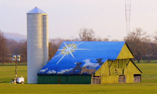
Everything I have written on this blog to date has been for barns with advertisements painted on the barn. This one is different. Nothing is being advertised, but instead, the season is celebrated. The barn isn't painted, but instead, a 400-pound mural is carefully unwrapped and placed on this barn every December. After Christmas has passed, The mural is carefully taken down and put into storage not to be seen for another 11 months.
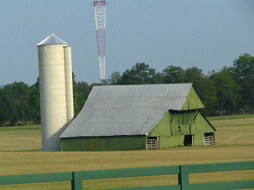
The farm now belongs to the Turner family. Cal Turner, Sr. was the founder of the Dollar General. Cal Jr. succeeded Sr. as president of the company but also has taken over the farm. Brentwood, like many cities has seen much growth over the decades, and many of the rural areas around the farm aren't rural anymore. Many real estate developers are anxiously waiting for the day this prime land can be turned into more mansions, or maybe even more retail stores. But for now, it's remains a farm and the 60 year old barn serves as a reminder as what life was like in the area decades ago.
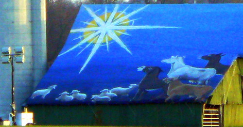
The 48' x 38' over-sized Christmas card was first seen in 1996. Turner Jr. commissioned local art-teacher Chris Tibbot to paint the mural. However, the art is not going to last forever. The painting is fragile since it is exposed to the elements. in years past, they had decided that they couldn't put it up anymore. So far, though, they think it can make it one more winter. This might be the last year it is shown or maybe next year, they'll bring it out for the last time again. Even the barn has become a concern. It was built in the 1940's, but over the years, it has slowly deteriorated to the point where now it's not used for anything other than the yearly display. A fierce storm came through this year that uprooted some of the nearby trees, but the barn held on.
Other things of note from the barn. On the left is a portable light which will illuminate the barn some nights during the season. The animals in the painting are sheep and donkeys and one white Charolais cow, which used to bred on this farm and were known as "Cal's cows." The large radio tower which is about a mile away is the signal tower for WSM 650 AM, the legendary station which has been the "home of the Grand Old Opry." At the time of the tower's construction in the 1930's it was called the tallest radio tower in the world. I'd like to get a picture at night, but so far, the light hasn't been on any time I've driven by.
See it on the map HERE. If you live in the area and are thinking about seeing it for yourself, this really could be the last year it's up, and they could take it down the day after Christmas.
posted by BrentKMoore at 4:06 AM
7 comments
![]()
![]()