6 Miles to Frisch's Big Boy
One of the more scenic drives out of Downtown Cincinnati is to drive east on U.S. Highway 52. This starts as Pete Rose Way by the Great American Ballpark, but becomes the Ohio River Scenic Byway, which is one of 99 National Scenic Byways designated by the U.S Department of Transportation. At one point, the road is known as Kellogg Rd., and a highlight is the famous Coney Island which opened as a theme park in 1887.
At some point, the highway needed to be widened and a large portion of U.S. 52 east of I-275 became a four-lane divided highway. Despite the widening, small stretches of the Old Kellogg Rd. still exist. On one of these stretches, just west of Eight Mile Road, hiding in the overgrowth is this barn painted to tell you how far Frisch's Big Boy Restaurant is.
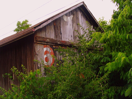
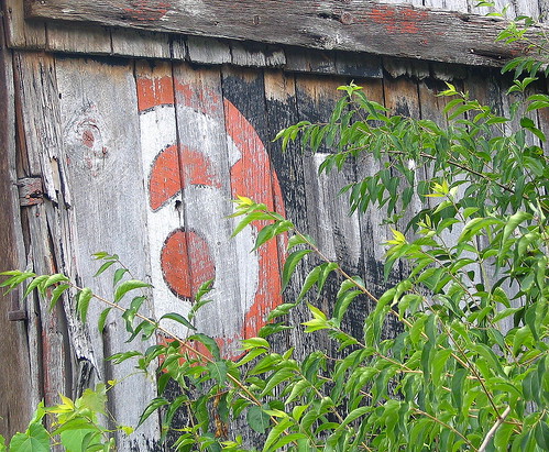
The New Highway is literally 25 feet to the right of this barn. For whatever reason, the paint that has survived the best is under the beam in the middle and the white 6, outlined in black in the red circle has remained well, except for the wood that has been replaced.
Frisch's Big Boy is a chain of Drive-Ins with over 100 locations surrounding the first one in Cincinnati. Their signature advertising landmark is the boy statue at most of the locations. The boy, wearing red and white checkerboard overalls holds a round tray with a Big Boy, a double-decker burger. The specific Frisch's advertised here is still open in New Richmond, Oh.
There were several different Big Boy Franchisees around the country, such as Bob's, Kip's, Marc's, JB's and Eat N' Park. Out of all of these, only Frisch's kept the Big Boy name. Locally, I remember eating at a Big Boy when I was young as the regional franchisee was Shoney's Big Boy. In 1984, Shoney's dropped the Big Boy name but kept a similar menu so they could expand more throughout the south.
This stretch of old highway, which is currently a dead-end street is being considered for a bike trail. More info Here.
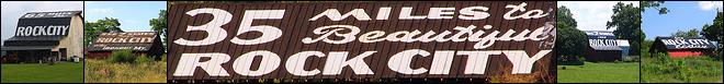
This barn is listed on OhioBarns.com as Advertising Barn #AdB35-31. The picture shown there was taken in the winter, making it possible to see all of the words.
The barn also appears on page 97 in the Simmonds book.
See it on a map HERE.
Lat & Lon: 39.035793oN \ -84.337387oW
At some point, the highway needed to be widened and a large portion of U.S. 52 east of I-275 became a four-lane divided highway. Despite the widening, small stretches of the Old Kellogg Rd. still exist. On one of these stretches, just west of Eight Mile Road, hiding in the overgrowth is this barn painted to tell you how far Frisch's Big Boy Restaurant is.
Frisch's
6 MILES TO Frisch's
BIG BOY
DRIVE IN RESTAURANT
& COFFEE SHOP
6 MILES TO Frisch's
BIG BOY
DRIVE IN RESTAURANT
& COFFEE SHOP
The New Highway is literally 25 feet to the right of this barn. For whatever reason, the paint that has survived the best is under the beam in the middle and the white 6, outlined in black in the red circle has remained well, except for the wood that has been replaced.
Frisch's Big Boy is a chain of Drive-Ins with over 100 locations surrounding the first one in Cincinnati. Their signature advertising landmark is the boy statue at most of the locations. The boy, wearing red and white checkerboard overalls holds a round tray with a Big Boy, a double-decker burger. The specific Frisch's advertised here is still open in New Richmond, Oh.
There were several different Big Boy Franchisees around the country, such as Bob's, Kip's, Marc's, JB's and Eat N' Park. Out of all of these, only Frisch's kept the Big Boy name. Locally, I remember eating at a Big Boy when I was young as the regional franchisee was Shoney's Big Boy. In 1984, Shoney's dropped the Big Boy name but kept a similar menu so they could expand more throughout the south.
This stretch of old highway, which is currently a dead-end street is being considered for a bike trail. More info Here.
This barn is listed on OhioBarns.com as Advertising Barn #AdB35-31. The picture shown there was taken in the winter, making it possible to see all of the words.
The barn also appears on page 97 in the Simmonds book.
See it on a map HERE.
Lat & Lon: 39.035793oN \ -84.337387oW
posted by BrentKMoore at 12:43 AM
![]()
![]()

0 Comments:
Post a Comment
<< Home