Resources used by this blog's author
There are a couple of websites and three books which are helpful in finding and learning about Rock City and other barns. Unfortunately barns crumble or are removed all the time and any of these can be out of date, including my information.
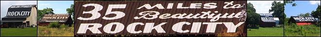
Website #1: The official Rock City website.
Here you can see what all the buzz is all about, learn the history of Rock City, Buy a souvenir and see pictures of some of the barns from the David Jenkins book below.
Website #2: OhioBarns.com
They are a wealth of information, all submitted by users of the website. They have a page on Rock City Barns. Generally if a barn is listed there, it was photographed in the last 5 years and is still around, but not always. They also have well done pages on Mail Pouch Tobacco, soft drink ads and much more. Each barn has its own page with a photo, the general location and is labeled in a format like: RCB 42-19-01 (A Rock City Barn in State 42, Tennessee, County 19, Davidson, and is the 1st barn in that county).
Book #1: Rock City Barns: A Passing Era by David Jenkins
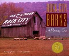
A great book where in the mid 1990's the author traveled the countryside with the Rock City's disorganized notes in an effort to find as many of the remaining barns as possible. A very worthwhile book.
Book #2 See Rock City Barns: A Tennessee Tradition by Anita Armstrong Capps
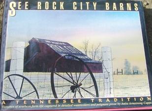
In the mid-90s, the author went to each of the barns in Tennessee that were still maintained by the Rock City painters and gave the story of the barn's owners, as well as a lovely portrait of that barn
Book #3: Advertising Barns by William Simmonds

Another good barn book, but focuses on all types of advertising barns.
Maps: For maps, I use Local.Live.com which is the Microsoft equivalent of Google Maps. Both website have similar features, and Google's is easier to use. You can see an aerial photo of the location, or just a map, or both at the same time. I use Microsoft's here for two reasons. 1) Local.Live.com has a permalink feature which makes it convenient to link in this blog. 2) While Google's imagery is in color, they do not have color photos for many rural areas, instead using very poor resolution satellite imagery. Microsoft has adapted their website from their old Terraserver website with of their USGS images. They are all black and white, but it is good resolution everywhere, although some areas might not have been rephotographed in 15 years. (by the way, Google Earth is the still about the coolest program ever. That is where I get my Latitude & Longitude info from.)
Milestones:
Created: July 29, 2006
100 Hits: Sept. 2, 2006
200 Hits: Nov 10, 2006
Website #1: The official Rock City website.
Here you can see what all the buzz is all about, learn the history of Rock City, Buy a souvenir and see pictures of some of the barns from the David Jenkins book below.
Website #2: OhioBarns.com
They are a wealth of information, all submitted by users of the website. They have a page on Rock City Barns. Generally if a barn is listed there, it was photographed in the last 5 years and is still around, but not always. They also have well done pages on Mail Pouch Tobacco, soft drink ads and much more. Each barn has its own page with a photo, the general location and is labeled in a format like: RCB 42-19-01 (A Rock City Barn in State 42, Tennessee, County 19, Davidson, and is the 1st barn in that county).
Book #1: Rock City Barns: A Passing Era by David Jenkins
A great book where in the mid 1990's the author traveled the countryside with the Rock City's disorganized notes in an effort to find as many of the remaining barns as possible. A very worthwhile book.
Book #2 See Rock City Barns: A Tennessee Tradition by Anita Armstrong Capps
In the mid-90s, the author went to each of the barns in Tennessee that were still maintained by the Rock City painters and gave the story of the barn's owners, as well as a lovely portrait of that barn
Book #3: Advertising Barns by William Simmonds
Another good barn book, but focuses on all types of advertising barns.
Maps: For maps, I use Local.Live.com which is the Microsoft equivalent of Google Maps. Both website have similar features, and Google's is easier to use. You can see an aerial photo of the location, or just a map, or both at the same time. I use Microsoft's here for two reasons. 1) Local.Live.com has a permalink feature which makes it convenient to link in this blog. 2) While Google's imagery is in color, they do not have color photos for many rural areas, instead using very poor resolution satellite imagery. Microsoft has adapted their website from their old Terraserver website with of their USGS images. They are all black and white, but it is good resolution everywhere, although some areas might not have been rephotographed in 15 years. (by the way, Google Earth is the still about the coolest program ever. That is where I get my Latitude & Longitude info from.)
Milestones:
Created: July 29, 2006
100 Hits: Sept. 2, 2006
200 Hits: Nov 10, 2006
posted by BrentKMoore at 6:32 PM
![]()
![]()


0 Comments:
Post a Comment
<< Home