How far to New York or New Orleans on U.S. 11?
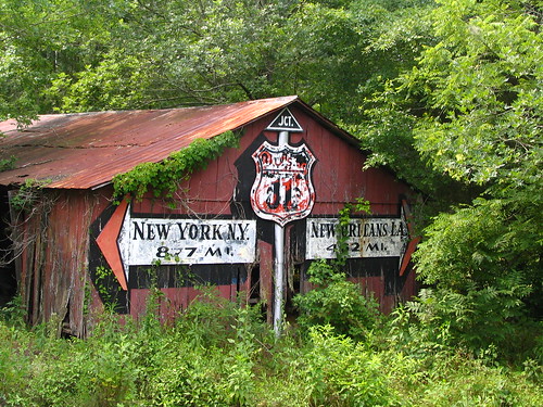
 his photo has become one of my favorite subjects, and is also one of the rare times that I have had a chance to go back and rephotograph something that I wish I had done better the first time. This barn is painted on both sides and also also has a roadfan element to it.
This barn is at the primary entrance and exit to Sequoyah Caverns in DeKalb County, Alabama. (I will write more about Sequoyah Caverns in a different blog post.) Upon leaving the Caverns, motorists are presented with a choice. Turn left and you are 877 Miles from New York, New York to the North, or turn right and you are 462 Miles from New Orleans, LA to the South.
To arrive at Sequoyah Caverns, signs point you onto U.S. Highway 11, and then onto County Road 731. Then, when your visit is done, you would get back on U.S. 11 with this barn at that intersection. U.S. 11 does go all the way from New Orleans to the U.S. / Canadian Border, north of Syracuse. (Ironically, it does not pass through New York City.) This highway was established in 1926 and follows much of the same route then as it does now, although it has been lengthened to 1645 total miles in 10 states.
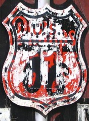
The metal pole in the center is an actual pole, not painted. The small triangular JCT. sign at the top has been affixed onto the pole, just as the U.S. 11 Shield has been. The black "shadow" of the U.S. 11 shield was painted on the barn, just like the arrows. The U.S. 11 sheild's paint has worn down to the point that you can see it used to be a sign for Phillips 66 gas stations. The black paint looks to have worn off much faster than the white paint on the sign.

Did this used to be an advertisement for Phillips 66 gas stations? If so, at some point, they must have dropped their sponsorship and U.S. 11 was painted over the Phillips 66. This was my Original conclusion. However, now I think the painter was just looking for a metal sign that was the correct shape and found an old Phillips 66 sign and painted over it. This barn likely would not have been a Phillips 66 ad unless there was one in either direction, I would think.
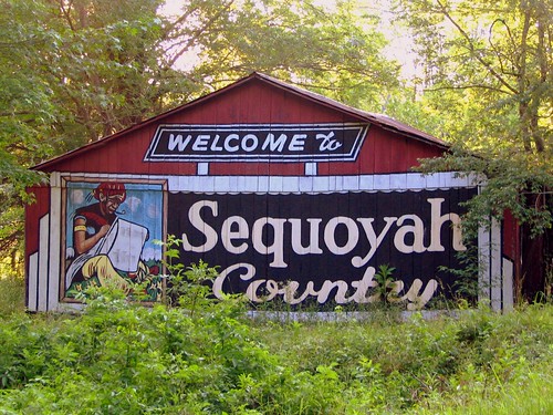
The other side has been better maintained.

When you follow the signs to get to the caverns on U.S. 11, this marks the entrance off the main road to go less than a mile to the parking lot for the Caverns. The Portrait on the left, I would assume, is Sequoyah devising the Cherokee alphabet.
It has been a long time, if ever, that this has been used as a barn, as it is inaccessible, unless you cut through the tall grass and weeds. There is a small stream between me and the barn when I took the first photo. There is a line of trees on the south side and the street to its north, but now is slowly becoming "reclaimed by nature."
I had never really paid attention to Sequoyah Caverns until I had driven U.S. 11 in pursuit of some Rock City Barns, but after a chance to research it more, my wife and I made a point to see it soon thereafter. More of their advertising barns will be discussed later.
Read more about Sequoyah Caverns, Here.
See it on a map, plus its aerial image Here.
My original photo is Here:


0 Comments:
Post a Comment
<< Home