Remember when...?
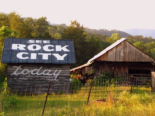
 emember When Every Barn Had Its SEE ROCK CITY Sign? This was the title of a magazine article written over 35 years ago that I recently came across. The article, written by Maxine Thompson and published in Georgia magazine in 1973, talked about the changes evident along the highways in the 8 years since the Johnson 1965 Highway Beautification Act. In a few short years, southern tourism changed dramatically, from it's heydey in the 40's and 50's. If the Interstates were going to bypass the entrances to all of the tourist attractions, you needed to have a really good sign to bring people in. But then, after the Act was passed, many signs had to be removed. Here's one that still remains today:
SEE
ROCK
CITY
Today
One of the best places to see these barns still intact today is in DeKalb County in Alabama, along U.S. Highway 11. US11 is one of the prominent U.S. Highways in America and this important stretch runs from Birmingham to Chattanooga. Many of thome miles is in the narrow valley between Lookout Mountain and Sand Mountain. Today, most motorists take Interstate 59, which parallels US11 very closely. So close, that the other barn in the picture is a painted advertisement for them, with an ad for Ruby Falls.
From the 1973 article,
"Don't Ride over one of these roads when you're in a hurry. Take time to browse, to read the faded old signs on the barns. One of these days the last one of them will complete its crumble into decay. When that happens, a segment of history will fade away."
Still so true this many years later!
On Ohiobarns.com, this is desgnated as #RCB 01-25-04.
In the Jenkins Book, it is on page 81F, and very faded.
To see it on a map, Click Here.
Lat & Lon: 34.67295oN \ 85.587412oW


